The Geology of Nineveh.
From the breached anticline of Sinjar to the karstic foundation beneath the Mosul Dam; from Cretaceous deep-water marl to Miocene gypsum and the world's largest known native-sulfur deposit — a survey of the rocks and structures that shape the Governorate.
The geology of Nineveh tells the story of the northern margin of the Arabian Plate over roughly the last hundred million years — from the deep-water carbonate sedimentation of the Late Cretaceous Tethyan ocean to the modern continuing collision with Eurasia that has built the Zagros and Taurus ranges to the north and east. The Governorate's landforms, its hydrocarbon basins, its mineral wealth, and the famously fragile foundation of the Mosul Dam are all expressions of this single regional history.
i. Tectonic setting
Iraqi territory sits on the northeastern edge of the Arabian Plate, which has been in slow-motion collision with the Eurasian (Iranian) Plate since the Late Cretaceous and continuously through the Cenozoic. The collision is responsible for the Zagros and Taurus mountain belts on the Iranian and Turkish sides; on the Iraqi side it has produced a wide foreland basin within the Arabian Plate margin.
Iraqi geologists conventionally divide the country into two main tectonic domains — the Stable Shelf, comprising the Inner Platform of the western desert, and the Unstable Shelf, comprising the Outer Platform that flanks the Zagros. The Unstable Shelf is further subdivided, from the foreland inward, into the Mesopotamian Foredeep, the Foothills Zone (Hamrin–Makhul), the Low Folded Zone, the High Folded Zone, the Imbricate Zone, and finally the Zagros Suture.
Nineveh Governorate occupies four of these zones. The bulk of its territory — the Tigris valley, the western Jazira, the southern desert — lies within the relatively quiet Foothills Zone of the Mesopotamian Foredeep, where Cretaceous and Cenozoic sediments have been gently flexed into broad anticlines and synclines. The single dramatic exception is the Sinjar Anticline in the western Jazira, which exposes the most prominent surface anticlinal structure within the Low Folded Zone and is the only place in the Governorate where pre-Eocene rocks reach the surface in any substantial outcrop. To the east, the foothill country of Sheikhan and Akre carries Nineveh's territory into the High Folded Zone, where steeper anticlines bring older formations to surface and elevations climb above 1,000 m. Earthquake focal depths in the Zagros Fold-Thrust Belt of Iraq typically range between 13 and 25 km, reflecting deformation at thin-skinned levels above the basement.
ii. Stratigraphic framework
The exposed rock record across Nineveh ranges from Late Cretaceous through Pliocene–Pleistocene, capped by Quaternary alluvium of the Tigris and its tributaries. The succession is overwhelmingly marine in its lower part, then transitional to continental in the Late Miocene and after — a shift that records the closing of the Neo-Tethys and the rise of the Zagros hinterland. The principal formations encountered in the Governorate, from oldest to youngest, are summarised in the column below.
iii. The Sinjar anticline
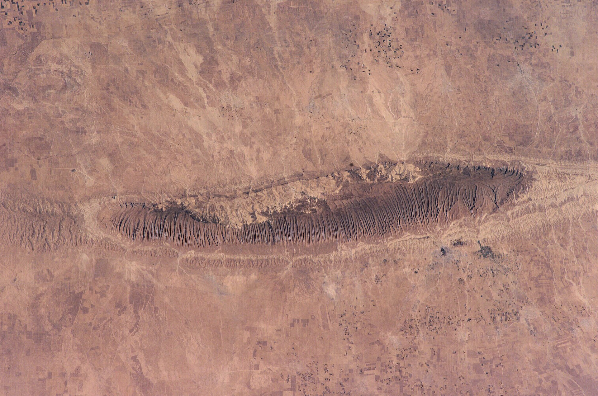
The Sinjar Mountains constitute the most spectacular surface structure in the Governorate and one of the classic structural exposures of Iraq. The range is a breached doubly-plunging asymmetric anticline — that is, an arch in the rocks whose crest has been eroded down through the youngest strata, exposing successively older units toward the centre of the structure. The fold has a steep northern limb, a gentler southern limb, and a clear northerly vergence. It runs east–west for some 100 km, with its high core (about 75 km long) inside Nineveh Governorate; the western 25 km extends into Syria.
Geologists place Sinjar within the Low Folded Zone of the Outer Platform, on the southwestern side of the broader Zagros foreland. The anticline is interpreted as a fault-related fold whose growth has been progressive through the Cenozoic, with renewed Late Miocene–Pliocene deformation as the Zagros front advanced. Small tight en-echelon folds are superimposed on its southwestern limb. Faulting at the surface is dominantly normal and reverse, with a northwest principal strike and subordinate northeast-trending sets.
Stratigraphically, the Sinjar core exposes the Late Cretaceous Shiranish Formation, succeeded outward by the Paleocene–Eocene Sinjar Formation (a reef–back-reef–fore-reef carbonate complex that takes its name from this very mountain), the Eocene Aliji and Jaddala formations, the Eocene–Early Miocene Serikagne, the Early Miocene Jeribe, and the Middle Miocene Fatha (Lower Fars) gypsum–marl–limestone evaporites. Late Miocene and younger continental molasse (Injana, Mukdadiya, Bai Hassan) rims the structure on its southern flank. The presence and biostratigraphic placement of Oligocene rocks within Sinjar has been a long-running scholarly debate, with planktonic-foraminiferal evidence pointing to a thin Late Oligocene interval at the top of the Jaddala and the base of the Early Miocene Aquitanian.
From the standpoint of regional geology, Sinjar is best understood as a giant outdoor laboratory: it preserves in surface outcrop the same sedimentary succession that lies, generally undeformed and at depth, beneath much of the Mesopotamian Foredeep to its south. For this reason, the formations exposed at Sinjar — particularly the Sinjar Formation reefal carbonates — serve as the type sections used by petroleum geologists working in the subsurface basins.
iv. Hydrocarbon basins
Nineveh contains a number of long-known hydrocarbon accumulations, most of them heavy-oil discoveries from the early decades of Iraqi exploration. Drilling began in the 1930s under British Oil Development Ltd, focused on the cluster of surface anticlines south of Mosul: Qaiyarah, Najmah, Jawan, and Qasab. Heavy oil (15–20° API) was discovered in the Miocene Euphrates and Jeribe limestones, and lighter oil in the underlying Cretaceous Hartha. Production from Qaiyarah began in the 1930s and has continued, with interruptions, ever since. The undeveloped Najmah field, a NW–SE-trending anticline 50 km south of Mosul, holds estimated reserves of 807 million barrels.
Further north, exploration after 1948 discovered the lighter-oil Ain Zalah and Butmah fields, where production comes from fractured Late Cretaceous Shiranish marly limestone and from the Triassic Kurra Chine dolomite at depth. Across the Governorate as a whole, an estimated 20% of Iraqi oil reserves lie in the north (Mosul–Kirkuk–Khanaqin axis), though the giant fields of southern Iraq (Rumaila, West Qurna, Majnoon) dwarf the northern accumulations.
Two reservoir intervals have particular importance for Nineveh: the Miocene Jeribe limestone (heavy oil at Najmah, Qaiyarah, Qasab, Jawan), and the Late Cretaceous Hartha. Source rocks are dominantly Late Jurassic to Early Cretaceous marine carbonates (Sargelu, Najmah Formation, Chia Gara), the same regional kitchen that has charged the Kirkuk and Bai Hassan fields to the southeast.
v. The Mishraq sulfur deposit
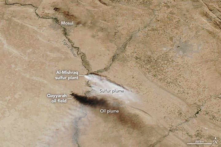
About 45 km southeast of Mosul, on the western bank of the Tigris near its confluence with the Greater Zab, lies one of the world's largest known native-sulfur deposits: the Mishraq field. The deposit occupies a doubly-plunging anticline of roughly 10 km² and contains an estimated 100 to 250 million tonnes of bioepigenetic native sulfur within the Middle Miocene Fatha Formation, at typical mining depths of around 200 metres.
The sulfur is the product of bacterial sulfate reduction. Anaerobic bacteria of the genus Desulfovibrio desulfuricans, supplied with hydrocarbon gases migrating up from deeper Jurassic source rocks and with sulfate from the dissolving Fatha gypsum and anhydrite, generate hydrogen sulfide; this is then oxidised in the contact zone with circulating groundwater to elemental sulfur, which precipitates within the formation as crystalline accumulations interleaved with bituminous marl. The same process appears in milder form throughout the Lower Fars (Fatha) Formation across the region, expressed in the hot springs of Hammam al-ʿAlīl, where water emerges at around 48 °C carrying a strong sulfurous signature.
Commercial mining at Mishraq began in 1972 under the state-owned Mishraq Sulphur State Company, using the Polish-modified Frasch hot-water process: superheated water at about 165 °C is injected through concentric pipes to melt the sulfur (its melting point is 112.8 °C) and bring it to surface in molten form. Production capacity reached 1 million tonnes per year, though actual output rarely matched it because of bitumen contamination and water losses. The site has twice been disastrously set ablaze, in 2003 and again in 2016 during the Daesh occupation of the area, releasing very large volumes of sulfur dioxide into the atmosphere.
vi. The Mosul Dam & its karst foundation
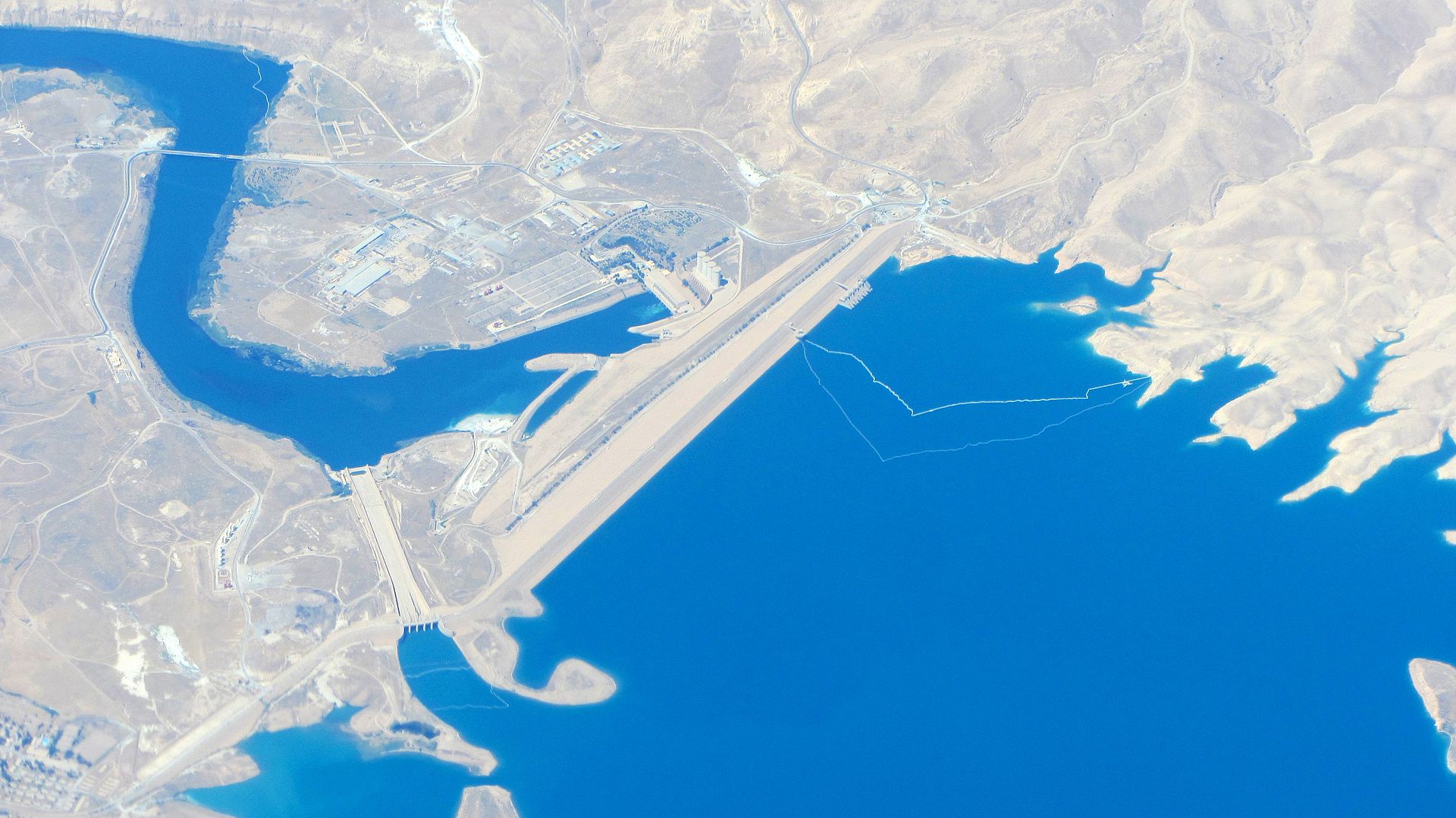
The Middle Miocene Fatha Formation that hosts the Mishraq sulfur is also the foundation rock of the Mosul Dam — and is the source of the dam's most discussed engineering challenge. The Fatha here consists of alternating beds of gypsum, anhydrite, marl and limestone. Each of these lithologies is to a greater or lesser degree soluble in circulating groundwater under pressure, and gypsum and anhydrite particularly so. Karst dissolution at the dam site predates the structure by centuries to millennia: photographs taken during the 1982–1983 excavation show extensive natural caves, breccias, and collapsed bedding already present in the foundation rock.
Once the reservoir was impounded in 1986, water seeping under hydraulic head accelerated this dissolution dramatically. The first sinkholes appeared within months on the right bank, around 150 metres from the abutment; a linear array of four further sinkholes opened along the dam axis between 1992 and 1998; another 15-metre-deep sinkhole appeared 150 metres downstream of the left toe in February 2002. A 2006 risk assessment by the United States Army Corps of Engineers described the dam, in terms of internal foundation erosion, as the most precarious large dam in the world. Continuous cement grouting from a dedicated 2,200-metre subsurface gallery has been the principal mitigation since 1986; a major rehabilitation programme by the Italian firm Trevi between 2016 and 2019 installed a refurbished grout curtain to a depth of more than 150 metres. Recent research has tested polymer-based chemical grouts (polyurethane and acrylic-cement composites) as a longer-term solution to gypsum solubility in the foundation.
The dam, in short, is engineered against its own foundation — a circumstance the original Iraqi-Italian designers of the 1970s recognised but, in pressing the project to completion, accepted. The geological setting that makes Mosul Dam useful (an upstream gorge with adequate reservoir capacity in the Tigris valley) and the geological setting that makes it perilous (Fatha Formation karst) are in fact one and the same.
vii. Surface processes & geomorphology
At the present day, the dominant geological processes shaping the Governorate are fluvial: the Tigris and its tributaries continue to incise the soft Late Miocene–Pliocene molasse, depositing terraces of alluvium that record both tectonic uplift in the Zagros foothills and Quaternary climatic cycles. The Tigris terraces around Mosul preserve at least four distinct levels, with the highest reaching some 30–40 metres above the modern floodplain.
Karstic processes — the same chemistry that operates beneath the Mosul Dam — produce minor caves, dolines and sinkholes throughout the Fatha outcrops of the foothills, particularly around Wadi Malleh and the western Sinjar area. Aeolian processes are significant in the southern Jazira and around Hatra, where active dunes and deflation surfaces are common. Active landslides have been mapped on the steep northern limb of the Sinjar Anticline and in the Akre foothills, where Sinjar Formation limestone has slid over the underlying Kolosh marls.
Earthquake activity in Nineveh is moderate by regional standards. The Governorate lies on the foreland side of the active Zagros front; recorded focal depths within the Zagros Fold-Thrust Belt of Iraq are typically 13 to 25 km, reflecting deformation above a relatively shallow basement. The historical record contains accounts of moderate earthquakes in the Mosul region (notable events in 1939 and 1949), but no events of devastating magnitude. The Mosul Dam itself was designed against modest seismic loading; the site survey identified small faults at the foundation, but no tectonic activity of consequence has been reported in the immediate dam area.
References
- Jassim, S.Z. & Goff, J.C. (eds.) (2006). Geology of Iraq. Brno & Prague: Dolin & Moravian Museum, 341 pp.
- Fouad, S.F. (2015). "Tectonic map of Iraq, scale 1:1,000,000, third edition." Iraqi Bulletin of Geology and Mining, 11(1), 1–7.
- Sissakian, V.K. (2013). "Geological evolution of the Iraqi Mesopotamia Foredeep, inner platform and near surroundings of the Arabian Plate." Journal of Asian Earth Sciences, 72, 152–163.
- Sissakian, V.K. (2005). "The stratigraphy of the exposed Cretaceous rocks in Iraq, as deduced from the results of the regional and detailed geological surveys (GEOSURV 1971–1996)." Iraqi Bulletin of Geology and Mining, 1(1), 1–20.
- Karim, S.A., Sissakian, V.K. & Al-Mukhtar, L.E. (2014). "Stratigraphy of the Oligocene–Early Miocene exposed formations in Sinjar area, NW Iraq." Iraqi Bulletin of Geology and Mining, 10(3), 1–30.
- Numan, N.M.S. & Al-Azzawi, N.K. (2002). "Progressive versus paroxysmal Alpine folding in Sinjar Anticline, northwestern Iraq." Iraqi Journal of Earth Science, 2(2), 59–69.
- Edgell, H.S. (2006). Arabian Deserts: Nature, Origin, and Evolution. Dordrecht: Springer, 592 pp.
- Aqrawi, A.A.M., Goff, J.C., Horbury, A.D. & Sadooni, F.N. (2010). The Petroleum Geology of Iraq. Beaconsfield: Scientific Press, 424 pp.
- Verma, M.K., Ahlbrandt, T.S. & Al-Gailani, M. (2004). "Petroleum reserves and undiscovered resources in the total petroleum systems of Iraq." GeoArabia, 9(3), 51–74.
- Adamo, N., Al-Ansari, N., Sissakian, V.K. & Knutsson, S. (2020). "Mosul Dam: Is it the most dangerous dam in the world?" Geotechnical and Geological Engineering, 38, 5179–5199.
- U.S. Army Corps of Engineers (2006). Mosul Dam Foundation Risk Assessment. Internal report.
- Vargas, J. (2020). "Mosul Dam — A multi-national dam foundation rehabilitation effort." ICOLD Conference Proceedings.
- Al-Sawaf, F.D.S. (1977). "Sulfate reduction and sulfur deposition in the Lower Fars Formation, northern Iraq." Economic Geology, 72(4), 608–618.
- Brown, M.A., Carlson, R.E. & Karim, A.M. (1979). "Economic geology of the Mishraq native sulfur deposit, northern Iraq." Economic Geology, 74(2), 484–495.
- Al-Banna, A.S. & Mohammed, A.A. (2022). "Mining evaluation of sulfur deposits in the Al-Mishraq area using a geostatistical method." Tikrit Journal of Pure Science, 27(6).
- Sissakian, V.K. & Fouad, S.F. (2015). Geological Map of Iraq, scale 1:1,000,000, 4th edition. Baghdad: GEOSURV.